For now, the symbolic impact is huge. “Reinventing dairy by removing cows from the equation” was once a science-fiction idea. With Canada’s green light, it’s officially a market reality — and the race to define the future of milk has entered a new phase.
The post Canada gives green light to Remilk’s cloned milk appeared first on Green Prophet.
Roman roads of the past
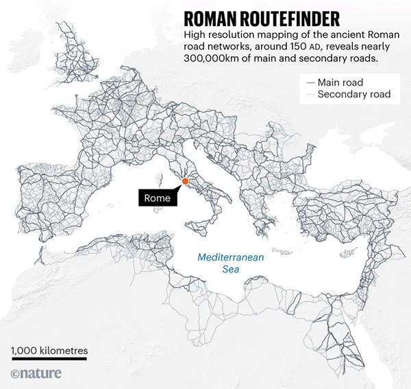
Two thousand years ago, all roads led to Rome. Now, thanks to modern data science, they finally do again — this time in high resolution. A newly released digital atlas Itiner-e what they call a “Google Maps for Roman roads.”It is being hailed as a kind of “Google Maps for the ancient world”, charting nearly 300,000 kilometres of Roman roads across Europe, the Middle East, and North Africa. The project stitches together countless archaeological and historical datasets into a single interactive network, revealing the sheer scale of the viae Romanae that once bound the empire together.
Ancient Roman roads
At its peak around AD 150, the Roman Empire stretched from Britain’s Hadrian’s Wall to the banks of the Euphrates, from the Atlas Mountains to the Black Sea. Its lifeblood was the road — engineered with stone, gravel, and astonishing precision — that carried soldiers, grain, ideas, and empire itself. But despite centuries of scholarship and excavation, our understanding of this network has remained incomplete.
Romans mastered self-healing mortar, which works well in wet environments
Although the roads are one of the best-known aspects of Roman history, it’s surprising how many details about them we still don’t know. According to the new dataset, the locations of only 3% of Roman roads are known with certainty; the rest have been inferred from satellite imagery, topographical analysis, and fragmentary archaeological evidence.
The map, created through a collaboration of classicists, GIS specialists, and open-data archivists, pulls together previously siloed regional studies — from Britain’s Watling Street to Israel’s Via Maris — into a single digital ecosystem. Each route can be explored interactively, complete with estimated construction dates, trade significance, and terrain context.
For ordinary viewers, it’s a revelation — a chance to visualize how Rome’s engineers carve through deserts, mountains, and marshes to keep an empire alive. It is, quite literally, the skeleton of Western civilization rendered as pixels and coordinates.
But this project isn’t just a nostalgic look backward. It’s also a powerful reminder of what sustainable infrastructure once meant. Roman roads were built to last millennia, with local materials, drainage systems, and low-maintenance stonework that endured centuries of weather and war. Many of today’s highways and rail lines still trace their original foundations. Roman concrete was self-healing and lasts until today.
In an age of asphalt sprawl, potholes, and short-term urban planning, the Roman network offers a strange kind of hope for our future. Ancient engineers designed for permanence and adaptation — concepts that modern infrastructure often neglects. The Romans understood maintenance as a civic duty, with roads meant to connect people, not just move things.
Roman law (Lex Julia Municipalis, 45 BCE) required local communities and landowners to maintain the sections of road passing through their territory. Public funds (the cursus publicus) supported major arteries, showing that upkeep was embedded in governance.
Some sustainability researchers see parallels between the Roman viae and today’s green corridors: both seek to balance movement, resilience, and local ecology.
The post Take me home, Roman roads appeared first on Green Prophet.